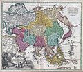
Fájl:1730 C. Homann Map of Asia - Geographicus - Asiae-homann-1730.jpg

Az oldal más nyelven nem érhető el.
A Wikipédiából, a szabad enciklopédiából

Eredeti fájl(4 000 × 3 492 képpont, fájlméret: 5,26 MB, MIME-típus: image/jpeg)

Összefoglaló

Johann Christoph Homann: Recentissima Asiae Delineatio : Qua Imperia, eius Regna, et Status, Unacum novissimis Russorum detectionibus circa Mare Caspium et Terram Yedso alias dict. per illor. Expedit. et Excursiones, factis sistuntur.   (Wikidata search (Cirrus search) Wikidata query (SPARQL)  Create new Wikidata item based on this file)
Művész
Johann Christoph Homann  (1703–1730)  wikidata:Q18508380
 
Leírás német orvos, kiadó és kartográfus
Születési és halálozási dátum 1703 Szerkesztés a Wikidatán 1730 Szerkesztés a Wikidatán
Születés és halálozás helye Nürnberg Nürnberg
Munkásságának helye
Nemzetközi katalógus
artist QS:P170,Q18508380
Mű címe
Recentissima Asiae Delineatio : Qua Imperia, eius Regna, et Status, Unacum novissimis Russorum detectionibus circa Mare Caspium et Terram Yedso alias dict. per illor. Expedit. et Excursiones, factis sistuntur.
Leírás
English: A rare and attractive 18th century map of Asia by German map publisher Johann Christoph Homann. Covers the entire continent of Asia as well as parts of Europe and northeastern Africa. This is essentially a revised and updated version of J. B. Homann’s 1712 map of Asia. Features some interesting and important updates. Most notably, we see the addition of the Kamchatka Peninsula in the upper right hand quadrant. The lower part of the peninsula is labeled “Kurilorum Regio”, no doubt an early reference to the Kuril Islands. While Hokkaido is not present, Japan itself is separated from the mainland by a small archipelago. Just east of these islands we see the Canal de Piecko, and beyond that a large and curious land mass labeled Compagnie Land. Compagnie Land is a mythical landmass that can be traced the work of an unknown Spanish pilot who supposedly traveled from China to New Span and published his finding along with the works of Thevenot. Present in both the 1712 map and this one, Compagnie’s Land could possibly be an early representation of Alaska or a misrepresentation of Hokkaido. Korea or Corea is present if misshapen in roughly the correct location. Further south New Guinea, New Britannia, Australia (New Holland), Hoch Land, and Carpentaria (part of Australia) are personated in tentative form with largely unexplored boundaries. At the center of the map the Caspian Sea is displayed according to the 1722 surveys of Karl van Verden. Bottom left quadrant features a decorative title cartouche displaying an enthroned king in Middle Eastern or Indian garb, exotic animals including a lion and leopard, trade goods, Camels, and bowing supplicants. A spectacular and important 18th century map of Asia.
Dátum 1730 körül
date QS:P571,+1730-00-00T00:00:00Z/9,P1480,Q5727902
(undated)
Méretei magasság: 19,5 hüvelyk (49,5 cm); szélesség: 22,5 hüvelyk (57,1 cm)
dimensions QS:P2048,19.5U218593
dimensions QS:P2049,22.5U218593
Leltári szám
Geographicus link: Asiae-homann-1730
Forrás/fényképész
Engedély
(Fájl újrafelhasználása)
Ez egy kétdimenziós, közkincs mű hű fényképe. Maga a mű a következő okból számít közkincsnek:
Public domain

Ez a mű közkincs abban az országban, ahol elkészítették, és minden olyan további államban, ahol a szerzői jogi védelmi idő a szerző élete plusz 100 év vagy kevesebb.


You must also include a United States public domain tag to indicate why this work is in the public domain in the United States.
A Wikimédia Alapítvány hivatalos álláspontja szerint „kétdimenziós közkincs művek hű reprodukciói közkincsnek számítanak”.
Ez a fénykép ezért szintén közkincsnek számít. Más jogrendszerekben ennek a műnek az újrafelhasználása korlátozott lehet; lásd a Commons:Reuse of PD-Art photographs lapot a részletekért.

Képaláírások

Adj meg egy egysoros magyarázatot arról, hogy mit mutat be ez a fájl
A rare and attractive 18th century map of Asia by German map publisher Johann Christoph Homann.

A fájl által ábrázolt elemek

mű tárgya

50d7f41d7c194c9d50a804aaa1b6cba16d8c371b

5 516 217 byte

3 492 képpont

4 000 képpont

Fájltörténet

Kattints egy időpontra, hogy a fájl akkori állapotát láthasd.

Dátum/időBélyegképFelbontásFeltöltőMegjegyzés
aktuális2011. március 16., 18:35Bélyegkép a 2011. március 16., 18:35-kori változatról4 000 × 3 492 (5,26 MB)BotMultichill{{subst:User:Multichill/Geographicus |link=http://www.geographicus.com/P/AntiqueMap/Asiae-homann-1730 |product_name=1730 C. Homann Map of Asia |map_title=Recentissima Asiae Delineatio : Qua Imperia, eius Regna, et Status, Unacum novissimis Russorum detect

Az alábbi lap használja ezt a fájlt:

Globális fájlhasználat

A következő wikik használják ezt a fájlt: